A.L. McMichael of the Digital Humanities Center uses digital and analog technologies to help students to map stories

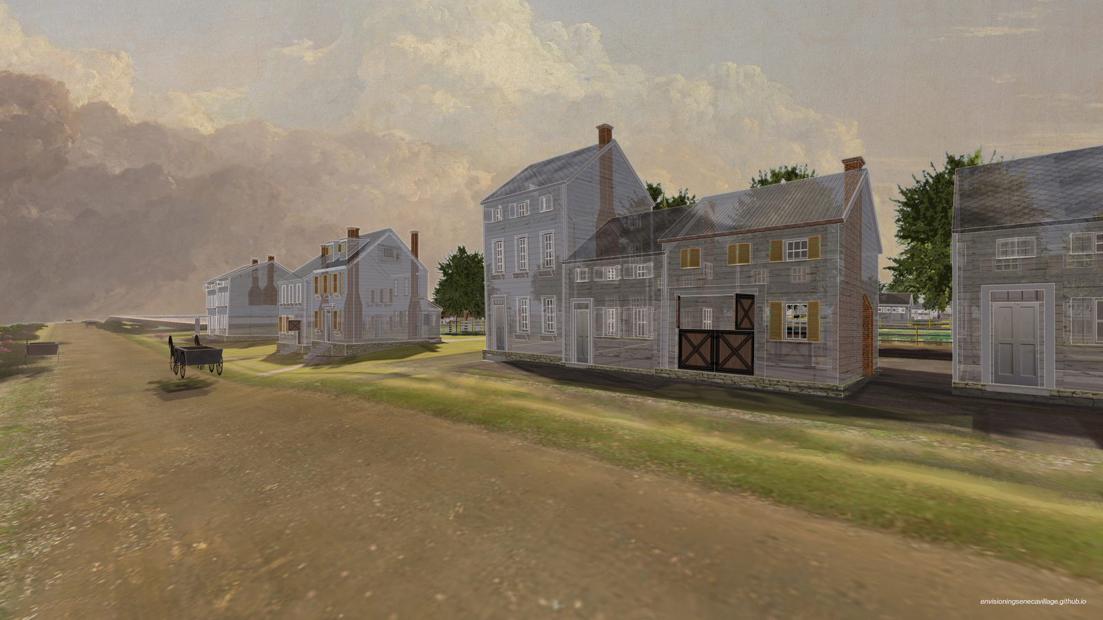
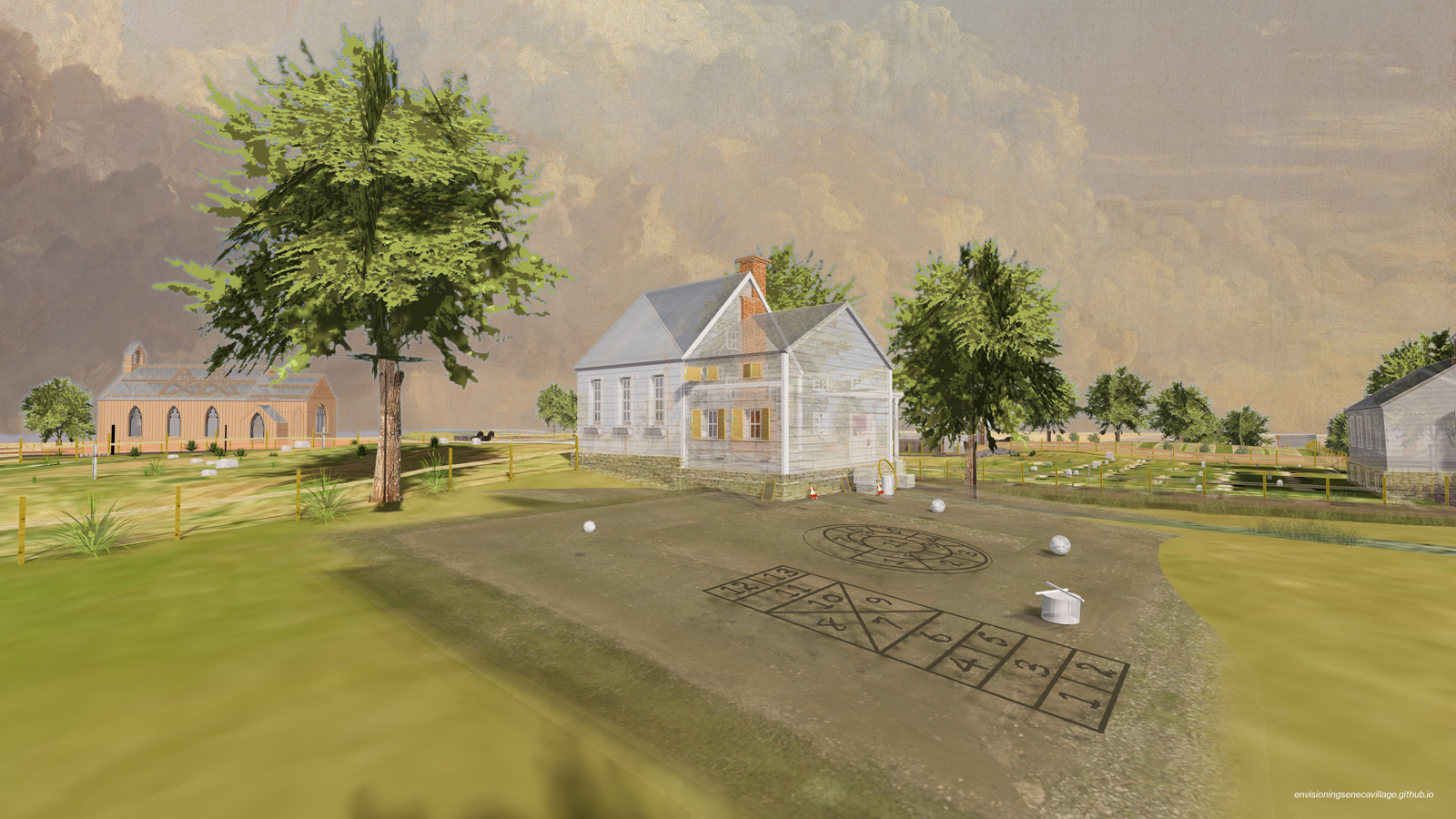
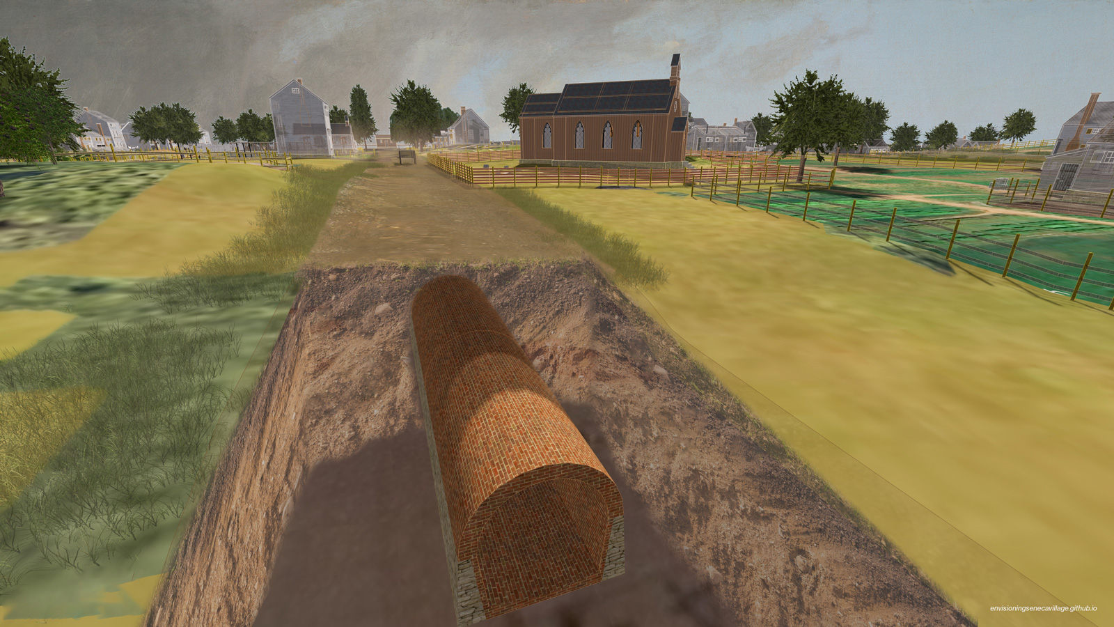
Before Central Park, there was Seneca Village, a thriving community founded by African Americans on five acres of what would become the landscaped expanse at the heart of Manhattan. For over three decades, the roughly six-block stretch between 82nd and 88th streets on the park’s western edge was home to an integrated population of mostly Black residents, with one-third Irish Americans and a small number of Germans. In 1857, through the use of eminent domain, the city of New York forcibly removed the community to make way for the park — leaving few vestiges of the once-vibrant village.
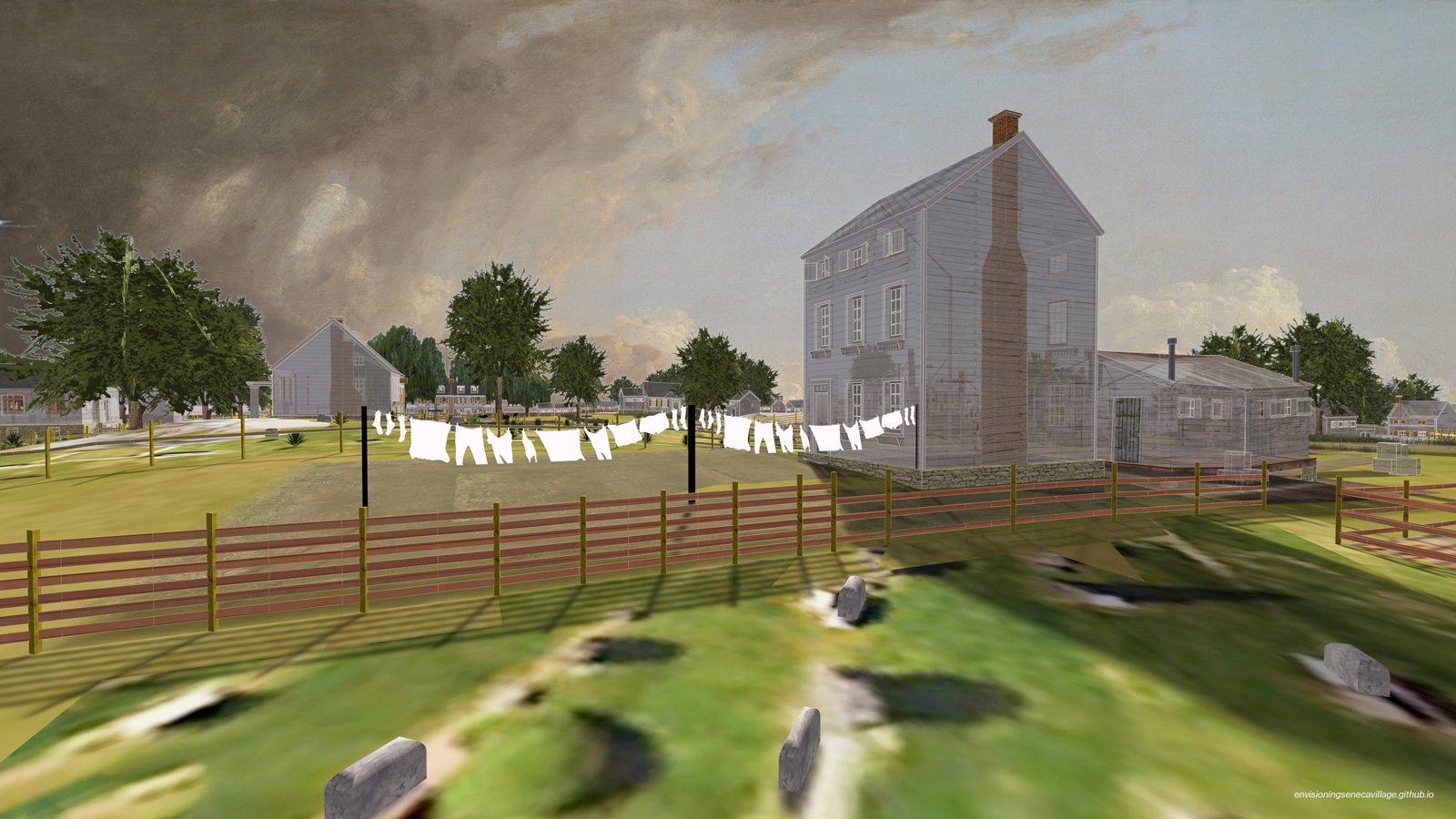
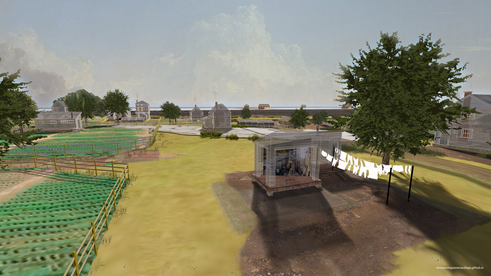
Today, a new project is preserving this nearly lost history — and commemorating the lives and significant contributions of the community’s residents — thanks to the joint efforts of four scholars, including Gergely Baics, Barnard associate professor of history and urban studies. Together, they launched Envisioning Seneca Village, an interactive 3D digital model of the community two years before its destruction. The site, launched on Juneteenth in 2024, shows the village on a late spring day, complete with homes, churches, a school, trees, streams, and details down to chickens and the toys that children living there would have had.

The project, Baics explains, was a true collaborative undertaking — one that reflects the spirit of Seneca Village’s inhabitants.
“We did this project because we thought it was the right thing to do,” says Baics, about the collaboration between himself, Meredith Linn GSAS ’08, associate professor of historical archeology at Bard Graduate Center, Leah Meisterlin GSAPP ’06, ’09, a cartographer and geospatial methodologist, and Myles Zhang CC ’19, an urban historian and Ph.D. candidate in architecture at the University of Michigan. “We had the resources and the tools to do something that is meaningful for the public history of New York and this community. So we decided to do it.”
The seeds of the idea for Envisioning Seneca Village were planted approximately two years ago when Baics was working on a project with Meisterlin, his frequent collaborator.
“We were analyzing 19th-century self-built residential areas within New York, which included many ‘shanties and shantytowns’ in Manhattan,” says Meisterlin. “We were pulling together our sources and thinking about the material and [thought], well, hold on, Seneca Village is always lumped into this discussion, and what we are finding through our mapping is just how unique and different from these ‘shanties’ it is. And through that [realization], this idea was born.”
To learn more about what distinguished Seneca Village from shantytowns, Baics and Meisterlin turned to Linn, a historical archaeologist and former Barnard professor. She joined the project, sharing a trove of data. Linn came to the project with critical knowledge, having co-authored the 2018 archaeological site report of Seneca Village with Barnard professor emerita Nan A. Rothschild, CUNY Graduate Center professor emerita Diana diZerega Wall, and historian Cynthia Copeland. (Linn is currently co-writing a book on the area with Rothschild and Wall.)
The team used a variety of historical records — including maps, New York census data, church and tax records, as well as letters of affidavit — and insights from the archaeological project to create the village’s virtual visualization. Maps from surveyors were particularly critical to the project, explains Linn, who referenced those made by Egbert Viele in 1855 and Gardner A. Sage in 1856.
“[Sage’s] job was to assess properties in order for the City to determine how much they would need to compensate landowners when they took their land invoking eminent domain [to build Central Park],” says Linn, who adds that Viele recorded the typography. “So those two maps and the census records form the core of the visual and documentary evidence that we draw on.”
While it was one thing to have an idea and data, it was quite another to turn it into a visual map. Enter Zhang, who created the digital village.
As there are no surviving photos or drawings of the village, Zhang’s representations had to rely on the data. Using the software SketchUp, Zhang integrated decades of historical and archaeological research with digital mapping methods, combining cartographic and social history with geographic information systems.
“Who writes history determines how certain communities and peoples and spaces are remembered. It’s really important for Seneca Village to be remembered as how the people who lived there experienced this place and not how other people describe it. And I think that using the tools of visualization makes that possible,” says Zhang. “Say the written word says that something is a shantytown. That’s what you believe, but when you have a visual of what this shanty looks like — well built and well maintained, with an orderly yard and garden, a shed filled with tools, and a sheltering tree — is that still a shanty? No.”
Beyond the visual representation of what life actually looked like in Seneca Village, the project uses text and annotations, says Baics, “to convey the vibrant life within the village” and to explain who lived in various properties, as well as how public buildings — spaces of worship or classrooms for children’s education and adult literacy — were used.
It took approximately one year for the team to create Envisioning Seneca Village with the help of research assistants Sarah Baybeck ’25, Maia Donald ’23, and Jesse Pearce ’24, as well as input from the Central Park Conservancy. There was also an advisory board, including Andrew Thomas Williams IV and Mareia M. Williams, two descendants of Andrew Williams, the first landowner of Seneca Village. “[The Williamses] shared information from their own family history and their perspectives about how the village’s history is so important in the present and for the future,” adds Linn. “They really helped to make our visualization better.”
These many minds were able to come together to create something historically groundbreaking. “So it really took a village to build this one single product,” says Baics.
This fall, the Central Park Conservancy began featuring Envisioning Seneca Village on its website. “The rediscovery of Seneca Village as a pre-park community revealed a unique African American story within the context of one of the most celebrated public spaces in the world,” says Jessica Striebel MacLean, a historian at the conservancy. “Envisioning Seneca Village offers a window into the past that is particularly powerful as a means of revealing the long-obscured history of a marginalized community.”
Though the website is ready to be explored now, it is only the beginning. The site currently includes a downloadable PDF that people can use for a walking tour in the park, and many new features are coming soon. The team behind Envisioning Seneca Village and the conservancy are planning workshops with teachers on how the website can be used in middle school and high school classrooms. There are also plans to video interview many of the advisory board members, whom Linn calls “amazing founts of knowledge.”
“One thing I feel this project does really well is bringing together the varied strengths of people who have different skills, different personalities, different life experiences,” adds Linn. “It shows how much can be accomplished when you bring together people who have differences — which speaks also to the spirit of Seneca Village itself.”
A.L. McMichael of the Digital Humanities Center uses digital and analog technologies to help students to map stories
Professor Benjamin Breyer created an AI tool that guides students in a first-year writing course
The Oscar-nominated actress says science informs her art and vice versa